More than just a city project

Great post on the Mississippi Drive Corridor Project and Planning for People and Places by Kevin Jenison, Communications Manager for the City of Muscatine!

City of Muscatine

032118 BlogI recently ran across the accompanying picture posted by Project for Public Spaces on Twitter and I could not help but think just how valid the point is and just how much it resonates with the reconstruction of the Mississippi Drive corridor.

“If you plan cities for cars and traffic, you get cars and traffic. If you plan for people and places, you get people and places.” – Fred Kent.

Kent is one of the founders of Project for Public Spaces and one of the leading authorities on revitalizing city spaces. His PPS biography also notes that he is one of the foremost thinkers in livability, smart growth, and the future of the city.

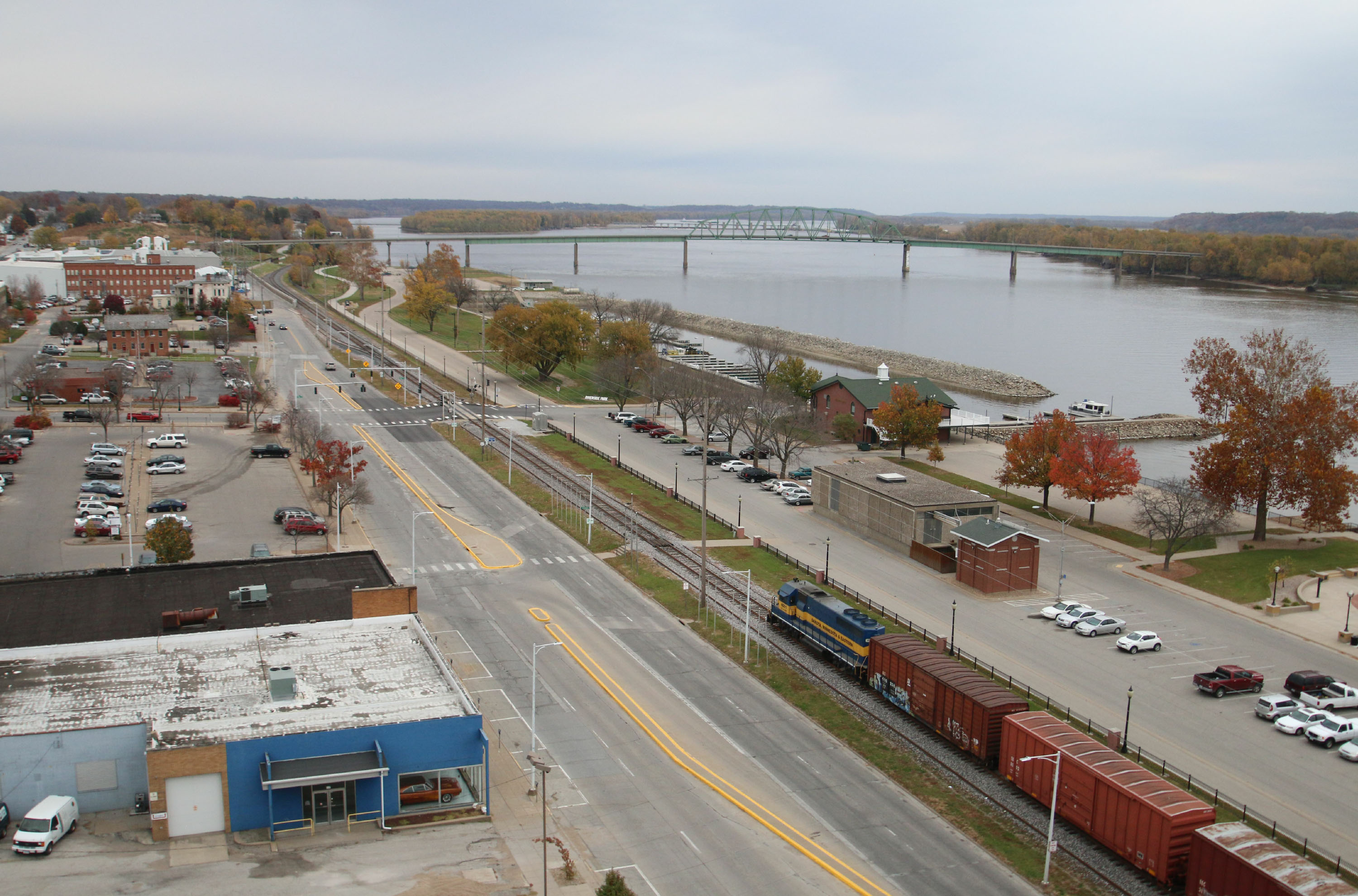
And the future of Muscatine is what the Mississippi Drive Corridor Revitalization Project is all about.

When U.S. 61 was the main thoroughfare through Muscatine it was designed and built for cars and traffic. It was a…

View original post 882 more words

A vision of connectivity

City of Muscatine

The vision began with a thought to transform a riverfront filled with old buildings, grain bins, and a switchyard into a park that the citizens of Muscatine could be proud of and visitors would want to make a destination. Out of that, according to Steve Boka, former Community Development Director for the City of Muscatine, came the realization of a strong connection between the riverfront and Downtown Muscatine, and the need for a safer Mississippi Drive.

“The thought was that once we embarked on creating this park, that would create interest in redevelopment of our downtown,” Boka said. “At that time there was not much going on in the second stories of our downtown.”

The vision expanded with the realization that the park would attract people to the area and that would ignite investment into the downtown area. But to get from the park to downtown people needed a safe…

View original post 1,079 more words

Walkability over driveability

City of Muscatine

04-25-17 Green Space - Riverfront Park 
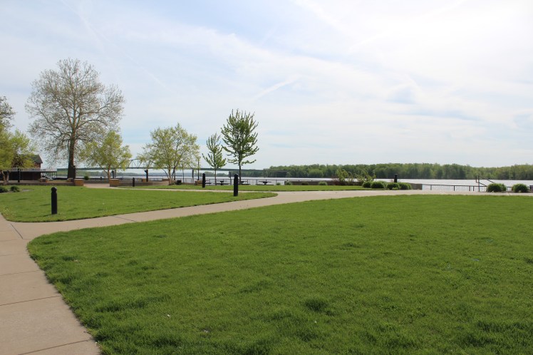
Green spaces like this one at Riverfront Park allow individuals to enjoy social interaction and nature along the banks of the Mississippi River. The wide sidewalks, sitting areas, play areas, and landscaping add to the walkable nature of the park. These and similar concepts will be used as the City of Muscatine continues its efforts to transform the downtown business district and other areas of the community into more pedestrian friendly gathering places.

It should not be a surprise to anyone that the City of Muscatine has, as one of their goals, the development of placemaking projects that will maintain local amenities for residents while also attracting and retaining a quality workforce. The placemaking philosophy, an idea that changes the emphasis of urban design from automobile traffic to pedestrian traffic, guides the public and private sectors of Muscatine in the development of plans for the riverfront, the downtown area, and…

View original post 537 more words

Radish Magazine – Going for green: Muscatine to receive EPA assistance for sustainable design


Check out Muscatine’s latest complete and green streets efforts on radishmagazine.com – Going for green: Muscatine to receive EPA assistance for sustainable design.

Source: Radish Magazine – Healthy living from the ground up

Mississippi Drive Corridor Vision and Project Kick-off Event

As we prepare for the September 1, 2015,  Kick-off of the Mississippi Drive Corridor Project, I wanted to pass on an educational piece that highlight’s the vision for transforming Mississippi Drive. This piece was put together after 30 city staff, business and property owners, health practitioners, regional planners and resident leaders came together under the direction of Dan Burden, national walkability expert, to begin to re-envision Mississippi Drive.

We identified what Muscatine currently lacks in the Mississippi Drive Corridor and found ways to potentially address those needs with changes to the built environment. Right now, we have an incredible opportunity to connect our downtown to the riverfront with this project. We can transform this corridor into a key focal piece for our community. Transforming Mississippi Drive will serve as a catalyst for economic development, community health, well-being and overall livability.

Please take a look at the Mississippi Drive vision piece and plan to attend the kick-off on Sept. 1. More details about the kick-off event will be released soon.

Click here for more info on the Kick-off Event!

Mississippi Drive Today

BZ_MuscatineIA_Before

Mississippi Drive Tomorrow?

BZ_MuscatineIA_After

Check out the following links!

Re-envisioning Mississippi Drive

Mississippi Drive Corridor Project Resource Page

Save the Date: September 1 to be Mississippi Drive Corridor Project Kick-off

City of Muscatine

Save September 1 and plan to attend a kick-off event for the Mississippi Drive Corridor Project. The event will be held at the Muscatine Riverfront, with specific location and time information to be released soon.


What is the Mississippi Drive Corridor Project?

It is a proposal for reconstructing the 1.6 miles of U.S. 61-Business (pavement and curb/gutter). It also includes street lighting, landscaping, gateway features, pedestrian crossings, sidewalk improvements, traffic signals, geometric improvements, storm drainage improvements, and road embankment work intended to improve flood protection. The work will focus on four distinct areas adjoining Muscatine’s Central Business District.  The improvement segments include the HNI Campus Area, Downtown Area, High Sidewalk (Bluff) Area and the Carver Corner Area.

The City of Muscatine plans for this project to meet the objectives of Muscatine’s complete street policy by improving both Muscatine’s quality of life and image. This project will provide a safe and attractive environment for street users of…

View original post 225 more words

The Imagining Livability Design Collection by Walkable and Livable Communities Institute

As the City of Muscatine begins the process of reconstructing and reimagining what the Mississippi Drive Corridor could be, here is a new tool provided by the Walkable and Livable Communities Institute and AARP:

Screen Shot 2015-07-16 at 3.04.18 PM

Here is a brief explanation of this new resource provided by the Walkable and Livable Communities Institute:

“What can livability look like in a rural context? How about a suburban one? And what can be done to make existing urban conditions more walkable and bikeable?

If you believe a picture can speak a thousand words, or you know people who are visual learners, then you will enjoy and want to share the latest free, educational resource created by the WALC Institute and AARP: The Imagining Livability Design Collection, a visual portfolio of tools and transformations.”

More information can be found at the following website:  http://www.walklive.org

So, click on the above photo and check out this great new resource!

Muscatine Building Improvements Loan Program

The City of Muscatine and three local banks, Central State Bank, First National Bank of Muscatine, and Community Bank and Trust, have partnered to launch a new loan program to assist property owners in Muscatine’s downtown to make improvements to their buildings and properties.

The program was born out of the need to stretch grant dollars for a specific downtown project so it could design, construct or upgrade the rear sides of a select few downtown buildings to take advantage of riverfront views that exist.

The local banks are committed to the City of Muscatine’s downtown and have set aside $1,000,000 for this loan program.

Property owners will first work with City of Muscatine staff to detail the improvements to be completed with a building improvement plan. With the City’s approval, applicants can approach the three lending institutions to secure funds for their improvement project. Loans will receive a fixed rate at 1% below prime for the first three years with a variable adjustable rate thereafter for a term no longer than 10 years. The initial district for these loans will run 12 City blocks. The loans will be a minimum of $5,000, and borrowers will still be subject to the banks normal credit standards.

Most improvements are eligible; however, there are some improvements that are ineligible such as no signage, inventory or modifications that take away from the historic character of the property and historic district.

Information and Documents:

Building Improvements Loan Program Documents
Application – Building Improvements Loan Program

For more information and a copy of the district map, please follow this link:  http://www.muscatineiowa.gov/924/Building-Improvements-Loan-Program 

image001

Let’s continue to make downtown Muscatine a great place to live, work and play!

City of Muscatine Placemaking: Blue Zones Built Environment Projects

The linked map gives you an idea of the many built environment changes that have been accomplished during the Muscatine Blue Zones effort.  The map includes projects that are presently underway as well as future projects (trails, sidewalks, community gardens, outdoor dining, and complete street projects)!  Great changes are coming to Muscatine thanks to our local community, local Blue Zones team, Dan Buettner and his Blue Zones team, Dan Burden and team, as well as City Staff and Council! June 2014 Blue Zones Map