Mississippi Drive Public Hearing Set For Feb. 2

The Mississippi Drive project is slated to begin in the Spring of 2017!

City of Muscatine

Mississippi Drive

Last Thursday, Jan. 19, there was a great turnout at the Public Meeting for the Mississippi Drive Corridor Project! Thank you to all who attended. At the meeting, City Council, citizens, and staff came together for an informal presentation and a chance to view the latest design plans.

If you would like to see design plans, but were not able to make it to the meeting, you may still view the latest map of design plans! It is on display at Public Works, 1459 Washington Street.

Next Thursday, Feb. 2, there will be a Public Hearing on Mississippi Drive at the City Council Meeting at 7 p.m. in Council Chambers. 

More information about the project and design concepts from the previous public engagement meetings can be found on the project website.

The construction for the Mississippi Drive Corridor Project is set to begin later this spring.

View original post

Save the Date: September 1 to be Mississippi Drive Corridor Project Kick-off

City of Muscatine

Save September 1 and plan to attend a kick-off event for the Mississippi Drive Corridor Project. The event will be held at the Muscatine Riverfront, with specific location and time information to be released soon.


What is the Mississippi Drive Corridor Project?

It is a proposal for reconstructing the 1.6 miles of U.S. 61-Business (pavement and curb/gutter). It also includes street lighting, landscaping, gateway features, pedestrian crossings, sidewalk improvements, traffic signals, geometric improvements, storm drainage improvements, and road embankment work intended to improve flood protection. The work will focus on four distinct areas adjoining Muscatine’s Central Business District.  The improvement segments include the HNI Campus Area, Downtown Area, High Sidewalk (Bluff) Area and the Carver Corner Area.

The City of Muscatine plans for this project to meet the objectives of Muscatine’s complete street policy by improving both Muscatine’s quality of life and image. This project will provide a safe and attractive environment for street users of…

View original post 225 more words

The Imagining Livability Design Collection by Walkable and Livable Communities Institute

As the City of Muscatine begins the process of reconstructing and reimagining what the Mississippi Drive Corridor could be, here is a new tool provided by the Walkable and Livable Communities Institute and AARP:

Screen Shot 2015-07-16 at 3.04.18 PM

Here is a brief explanation of this new resource provided by the Walkable and Livable Communities Institute:

“What can livability look like in a rural context? How about a suburban one? And what can be done to make existing urban conditions more walkable and bikeable?

If you believe a picture can speak a thousand words, or you know people who are visual learners, then you will enjoy and want to share the latest free, educational resource created by the WALC Institute and AARP: The Imagining Livability Design Collection, a visual portfolio of tools and transformations.”

More information can be found at the following website:  http://www.walklive.org

So, click on the above photo and check out this great new resource!

Muscatine’s Mississippi Drive Corridor Project

Mississippi Drive Corridor Project:  A complete streets project and signature entryway into the City of Muscatine!

The City of Muscatine, Iowa, is soliciting qualifications from interested engineering firms to provide design services and other related work for the “Mississippi Drive Corridor Reconstruction Project”. This proposal includes the reconstruction of 1.6 miles of U.S. 61-Business (pavement and curb/gutter); street lighting, landscaping, gateway features; pedestrian crossings and sidewalk improvements; traffic signals and geometric improvements; and storm drainage improvements and roadway embankment work intended to improve flood protection. The work would focus on four distinct areas adjoining Muscatine’s Central Business District. The improvement segments include the HNI Campus Area, Downtown Area, High Sidewalk (Bluff) Area and the Carver Corner Area. The objectives for the proposal include meeting the objectives of Muscatine’s complete street policy by improving both Muscatine’s quality of life and image by providing a safe and attractive environment for street users of all ages and abilities such as motorists, pedestrians, bicyclists, mass transit, children, senior citizens, individuals with disabilities, freight carriers, emergency responders and adjacent land users; modernizing U.S. 61-Business through the reconfiguration and reconstruction of the sub-standard, deteriorated roadway; and enhancing aesthetics throughout the corridor that are consistent with Muscatine’s riverfront improvements. Work will include plan development, public meetings, design development, final design, technical specifications and drawings.

Mississippi Drive Corridor Project Request for Qualifications (RFQ)

The following resources provide further background information, technical data, and the potential vision for the Mississippi Drive Corridor Project.  These resources can be found at the following link: http://www.muscatineiowa.gov/941/Mississippi-Drive-Corridor-ProjectMississippi Drive Corridor Study

  • Corridor Alignment and Geometric Alternative Analysis
  • Traffic Analysis Geometric Alternative
  • IA 92 Pavement History Map
  • Mississippi Riverfront Study June 1997
  • Vision for Mississippi Drive
  • Comprehensive Plan
  • Complete Street Policy

The City is currently in the process of selecting an engineering firm to bring this project from concept to reality.

Our first step will be to engage the community, its residents and key stakeholders in a formal public process.

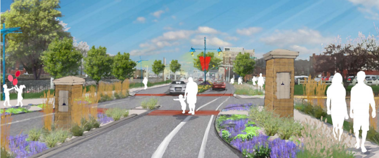
Mississippi Drive Today

BZ_MuscatineIA_Before

Mississippi Drive Tomorrow?

BZ_MuscatineIA_After

These images were prepared for Muscatine by Dan Burden and the Blue Zones Team.  “Dan Burden provides a framework and action plan for communities to change their environments into safe, walkable, bike-able and livable communities where individuals and businesses thrive.” (http://www.bluezones.com/walkability-3/)

For more information on Blue Zones, Dan Buettner, and Dan Burden’s efforts please see the following link: http://www.bluezones.com

Stayed tuned for more information and please participate!

City of Muscatine Placemaking: Blue Zones Built Environment Projects

The linked map gives you an idea of the many built environment changes that have been accomplished during the Muscatine Blue Zones effort.  The map includes projects that are presently underway as well as future projects (trails, sidewalks, community gardens, outdoor dining, and complete street projects)!  Great changes are coming to Muscatine thanks to our local community, local Blue Zones team, Dan Buettner and his Blue Zones team, Dan Burden and team, as well as City Staff and Council! June 2014 Blue Zones Map