Walkability over driveability

City of Muscatine

04-25-17 Green Space - Riverfront Park 
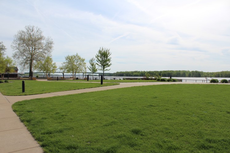
Green spaces like this one at Riverfront Park allow individuals to enjoy social interaction and nature along the banks of the Mississippi River. The wide sidewalks, sitting areas, play areas, and landscaping add to the walkable nature of the park. These and similar concepts will be used as the City of Muscatine continues its efforts to transform the downtown business district and other areas of the community into more pedestrian friendly gathering places.

It should not be a surprise to anyone that the City of Muscatine has, as one of their goals, the development of placemaking projects that will maintain local amenities for residents while also attracting and retaining a quality workforce. The placemaking philosophy, an idea that changes the emphasis of urban design from automobile traffic to pedestrian traffic, guides the public and private sectors of Muscatine in the development of plans for the riverfront, the downtown area, and…

View original post 537 more words

2nd Mississippi Drive Engagement Event Was a Success!

This slideshow requires JavaScript.


Thanks to the over 175 participants in our 2nd Mississippi Drive Corridor Event! Your time and participation is much appreciated and will make for a better project. Stay tuned for more!

City of Muscatine

Thank you to everyone who participated in the 2nd public engagement event for the Mississippi Drive Corridor Project! We were pleased with the attendance and high level of participation by community members. The event was held on Tuesday, Nov. 10 at the Riverview Center. There were about 175 people who came to hear about potential design plans and provide feedback in a public opinion poll.

If you were unable to attend and would like to take a look at initial design concepts and submit feedback, you may do so at our engineering firm Bolton & Menk’s website: http://bolton-menk.com/mississippidrive.

The Mississippi Drive Corridor Project is exciting for Muscatine! Not only will the road be redone, but Muscatine will be better connected as a result of this project. Mississippi Drive is the key connector of downtown and the riverfront. As our community comes together to create a shared vision for the future of Mississippi Drive…

View original post 14 more words

The Imagining Livability Design Collection by Walkable and Livable Communities Institute

As the City of Muscatine begins the process of reconstructing and reimagining what the Mississippi Drive Corridor could be, here is a new tool provided by the Walkable and Livable Communities Institute and AARP:

Screen Shot 2015-07-16 at 3.04.18 PM

Here is a brief explanation of this new resource provided by the Walkable and Livable Communities Institute:

“What can livability look like in a rural context? How about a suburban one? And what can be done to make existing urban conditions more walkable and bikeable?

If you believe a picture can speak a thousand words, or you know people who are visual learners, then you will enjoy and want to share the latest free, educational resource created by the WALC Institute and AARP: The Imagining Livability Design Collection, a visual portfolio of tools and transformations.”

More information can be found at the following website:  http://www.walklive.org

So, click on the above photo and check out this great new resource!

City of Muscatine Complete Streets Policy

The above photo is from the Walkable and Livable Communities Institute (WALC).  Their website and more information on complete streets can be found at http://www.walklive.org.  The WALC Institute helps to create healthy, connected communities that support active living and that advance opportunities for all people through walkable and bikeable streets, livable cities and better built environments.

The City of Muscatine has adopted a complete streets policy.  A complete street is a safe, accessible, and convenient street for all users regardless of transportation mode, age, or physical ability. Complete streets adequately provide for bicyclists, pedestrians, transit riders, and motorists, by matching the needs of travelers to the uses surrounding a street. It provides safe travel for people using any legal mode of travel. Every complete street looks different with component features varying based on context, topography, road function, the speed of traffic, pedestrian and bicycle demand, and other factors. Based on context, common features of complete streets include: sidewalks, paved shoulders, bike lanes, safe crossing points, accessible curb ramps, pedestrian refuge medians, bus stop access, sidewalk “bump-outs” at intersections, and access to adjacent trails in a “corridor”.

Complete Streets Policy

Additional information and awards: